Viaggi consigliati
Risolto un altro mistero della Gioconda,
sullo sfondo c’è il ponte Romito
 0
0
Una ricerca coordinata dallo storico Silvano Vinceti conduce al manufatto di Laterina
In provincia di Arezzo. Identificate anche le piramidi di terra del paesaggio a cui Leonardo si è ispirato
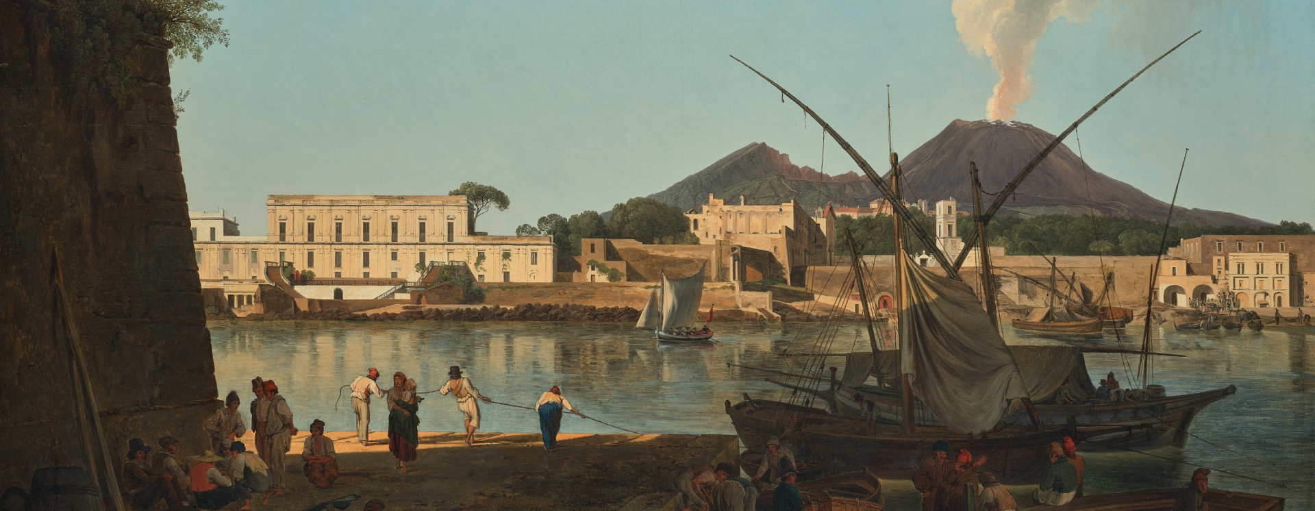
E’ il ponte Romito di Laterina in provincia di Arezzo quello che Leonardo dipinse nel paesaggio della Gioconda. Una ricerca coordinata dallo storico Silvano Vinceti, già autore in passato di altre importanti scoperte sul ritratto più famoso del mondo, sembra lasciare pochi dubbi su un mistero che negli anni ha alimentato innumerevoli dispute. Tra le tesi sostenute, quelle che hanno suscitato più clamore rinviano al ponte medievale di Bobbio, in provincia di Piacenza, e al ponte a Buriano in provincia di Arezzo. Ma ora quest’ultima ricerca – condotta grazie anche alla collaborazione dell’associazione culturale La Rocca e basata su nuovi documenti storici e comparazioni fra fotografie attuali e quanto raffigurato nel dipinto – ha reso possibile individuare il vero ponte della Gioconda.
 lo
lo
“Si tratta del ponte etrusco-romano Romito o ponte di Valle – spiega Vinceti – collocato nel comune di Laterina in provincia di Arezzo. Attualmente del ponte rimane un solo arco, ma nel periodo tra il 1501 e il 1503 il ponte era in funzione e frequentatissimo, come attesta un documento sullo stato dei manufatti nelle proprietà della famiglia dei Medici, ritrovato negli archivi di Stato di Firenze”. E proprio in quel periodo Leonardo si trovava in Val d’Arno, prima al servizio di Cesare Borgia, detto il Valentino, e poi del gonfaloniere della Repubblica di Firenze Pier Soderini. Il ponte Romito aveva quattro arcate, poggiava su due falesie, faceva parte di un diverticolo o scorciatoia che permetteva di accorciare di parecchi chilometri il tragitto fra Arezzo, Fiesole e Firenze. Il ponte di Bobbio, invece, ha più di sei arcate, e quello a Buriano ne ha sei. Inoltre questi manufatti sono collocati su un terreno pianeggiante.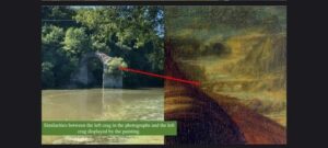
“Diverse sono le corrispondenze che intercorrono fra il ponte Romito – sottolinea Vinceti – le particolari morfologie dell’Arno in quel tratto di territorio e quanto riportato da Leonardo nel paesaggio alla sinistra della nobildonna raffigurata nel famoso dipinto. Queste corrispondenze sono emerse grazie alle immagini riprese da un drone che ci hanno consentito di evidenziare la presenza di due falesie nel lato sinistro e destro del ponte Romito e l’andamento sinuoso dell’Arno, così come raffigurati nel dipinto della Gioconda”.
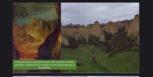
E la ricostruzione virtuale del ponte, realizzata in base alla larghezza dell’Arno nel tratto in cui si trova il ponte Romito, evidenzia una forte similitudine con il ponte presente nel ritratto. Lo stesso si può affermare per la forma e la grandezza dei quattro archi. “Significativi – aggiunge Vinceti, che è anche presidente del comitato nazionale per la valorizzazione dei beni storici culturali e ambientali – sono inoltre i documenti storici che certificano come Leonardo in quel periodo risiedesse spesso a Fiesole, presso uno zio prete che si chiamava Amadori o Amadoro. L’analisi delle immagini scattate col drone e dei documenti storici ci ha permesso di individuare, con un alto livello di probabilità, il paesaggio dipinto nella parte bassa a sinistra della Gioconda. Ovvero il complesso di balze o piramidi di terra nella zona del Val d’Arno superiore a cui Leonardo si è ispirato. E a questo proposito sono di fondamentale importanza alcuni disegni di balze presenti nel Codice Hammer (o Codice Leicester), famoso manoscritto di Leonardo databile tra il 1506 e il 1510”.
dav
Another Mona Lisa mystery solved
In the background stands the Romito bridge.
Research coordinated by the historian Silvano Vinceti leads to the Laterina artifact
In the province of Arezzo.
The earth pyramids of the landscape that inspired Leonardo have also been identified.
It is the Romito di Laterina bridge in the province of Arezzo that Leonardo painted the landscape of the Mona Lisa. Research coordinated by the historian Silvano Vinceti, the author of previous important discoveries on the most famous portrait in the world, seems to leave little doubt about a mystery that has fueled countless disputes over the years. Among the thesis incurred, those that have caused the most clamor refer to the medieval bridge of Bobbio, in the province of Piacenza, and the bridge in Buriano in the province of Arezzo. But now this latest research – conducted in thanks to the collaboration of the cultural association La Rocca and based on new historical documents and comparisons between current photographs and what is depicted in the painting – has made it possible to identify the real Mona Lisa bridge.
“It is the Etruscan-Roman bridge, Romito, or Ponte di Valle – explains Vinceti – located in the municipality of Laterina in the province of Arezzo – Italy. Only one arch remains of the bridge today, but in the period between 1501 and 1503 the bridge was in operation and very busy, as attested by a document on the state of artifacts of the Medici family properties, found in the State archives of Florence”. It was precisely at that time that Leonardo was in the Val d’Arno, first at the service of Cesare Borgia, known as the Valentino, and then for the gonfalonier of the Republic of Florence, Pier Soderini. The Romito bridge had four arches, rested on two cliffs, was part of a byway or shortcut that made it possible to shorten the journey between Arezzo, Fiesole and Florence by several kilometers. The Bobbio bridge, on the other hand, has more than six arches, and the one in Buriano has six. Furthermore, these artifacts are situated on flat ground.
“There are various correspondences between the Romito bridge – underlines Vinceti – the particular landforms of the Arno in that stretch of territory and what Leonardo portrayed in the landscape to the left of the noblewoman depicted in the famous painting. These correspondences emerged thanks to the images taken from a drone which allowed us to highlight the presence of two cliffs on the left and right side of the Romito bridge and the sinuous course of the Arno, as depicted in the painting of the Mona Lisa”.
The virtual reconstruction of the bridge, created on the basis of the width of the Arno in the section where the Romito bridge is located, highlights a strong similarity with the bridge in the portrait. The same can be said for the shape and size of the four arches. “Significant – adds Vinceti, who is also President of The National Committee for the Enhancement of Historical, Cultural and Environmental Heritage – there are also historical documents which certify that Leonardo often resided in Fiesole at that time, with an uncle who was a priest, named Amadori or Amadoro .
The analysis of the images taken with the drone and of the historical documents have allowed us to identify, with a high level of probability, the landscape painted in the lower left part of the Mona Lisa. That is to say the formation of bluffs or earth pyramids in the upper Val d’Arno area that inspired Leonardo. And in this regard, some drawings of bluffs present in the Hammer Code (or Leicester Code), Leonardo’s famous manuscript dating from between 1506 and 1510, are of fundamental importance.”